
Article Sidebar
Downloads
Main Article Content
Abstract
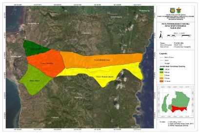
Selayar Regency occupies the sixth position for stunting in South Sulawesi, with a prevalence of 32.1%. This problem is exacerbated by the community's limited access to information about stunting, so educational efforts are needed to disseminate stunting information presented using spatial mapping patterns. This activity aimed to develop village maps and identify high-stunting areas using spatial maps to improve the quality of community development. This map-making activity begins with data collection, and then data processing is carried out using ArcGIS software, digitization methods, and spatial analysis in the form of overlay analysis. Maps that have gone through the layout stage are then printed and submitted to the village government and health workers. The utilization of this map of strategic locations such as village offices, health centers, and local nutrition centers assesses the success of this services activity as a source of information in determining priority steps in preventing and handling stunting cases.
Keywords
Article Details

This work is licensed under a Creative Commons Attribution-NonCommercial 4.0 International License.